Montag, 20. Dezember 2010

Donaukartografie; Wien

Künstlerische Gestaltung der Station „Donaustadtbrücke und Donaumarina, 1220 Wien
Kooperation Wiener Linien und KÖR Kunst im öffentlichen Raum Wien
im Rahmen der U2 Verlängerung
Ausbaustufe 3: Verlängerung U2 - Nord bis Aspernstraße

Donaukartografie, Landschaft als Karte als Malerei


Satelitenkarte (http://www.wien.gv.at/stadtplan/)


1942. Die Putzfrau bittet um Auskunft, während sie das Arbeitszimmer des Professors reinigt und vor einer wandfüllenden Weltkarte steht: „Was ist denn das große Rote da?“ Das seien die Verein¬igten Staaten. „Und das riesige Grüne?“ Das sei die Sowjetunion. „Und wo ist denn nun das Großdeut¬sche Reich?“ Der Professor deutet auf den kleinen blauen Klecks in der Mitte Europas. Die Putzfrau, zu Tode erschrocken: „Weiß das der Führer?“

Ein Bahnhof ist ein Ort des Durchganges, des Transits, an dem der Reisende ungewollt warten muss, bis es weiter geht und der Zug kommt, der ihn durch die Landschaft befördert. Der Reisende schlendert über den Bahnsteig, versucht sich abzulenken, die Zeit zu überbrücken. In anderer Weise überbrückt die Donaukartografie die Zeit: Sie stellt die sich über die Jahrhunderte hinweg ständig wandelnde und überlagernde Flussverläufe der Donau dar, das als Karte auf den Bahnsteig graviert ist, sodass der Reisende während er über den Bahnsteig flaniert, sich sozusagen gleichzeitig durch Raum und Zeit be¬wegt.

Die Donau ist das landschaftliche Wahrzeichen Wiens. Sie fließt seit Jahrtausenden aus den Alpen kommend durch das Wiener Becken, in einem sich ständig wandelnden Bett, das sich in seiner Aus¬dehnung weit über die Grenzen Wiens hinaus erstreckt. Erst mit der Donauregulierung wurde dieser Prozess des unbehinderten Mäandrierens beendet. Dieses Verschwinden und an anderer Stelle wieder Auftauchen des Flussbettes, dabei Sandbänke schaffend, kleine Inseln hinterlassend, jedoch nirgendwo festen Grund findend, prägte die Geschichte der Stadt: Wien zeugt von dem instabilen und unstruktu¬rierten Gemenge ehemaliger Landschaften. Der Fluss dreht sich ostwärts, dann westwärts, dann wieder zurück. Innerhalb weniger Jahrzehnte entwickelten sich wiederholt völlig neue Geometrien, so dass über die Jahrhunderte ein Labyrinth sich überlagernder Flussläufe entstand, in dem jeder Einzelne auf unvermeidliche Weise langsam über die Zeit verschwindet, um wieder durch einen Anderen in neuer Form ersetzt zu werden. Diese ganzen alten Wege des Flusses, eingezeichnet in Steine und Erde, die einst durch die Hinterhöfe der Bauern flossen, sind eigentlich Fossile einer Landschaft. Verlorene Flüsse eingeprägt in die Landschaft. Die Tatsache, dass Wien in ein solches Zentrum mobilen Untergrundes erbaut wurde, erscheint ungewöhnlich und einzigartig: Eine Stadt gebaut auf hunderten von Hektar abgelagertem Auen¬schlamms, -lehms,–tons und Kiesen, der sich über die Jahrhunderte verfestigte.

Für die Bahnhöfe Donaumarina und Donaustadtbrücke wurde eine Idee entwickelt, die diese beson¬dere Situation, in die hinein Wien gegründet ist, berücksichtigt. Ausgangspunkt ist die geografische und städtebauliche Situation, die sich aus folgendem zusammensetzt: einerseits die mit dem Neubau der beiden Bahnhöfe geschaffenen Brückensituation über die Donau hinweg und anderseits der Erweiter¬ung Wiens durch ein Entwicklungsgebiet - der Donaumarina -, in dem sich Arbeit und Leben vereinen soll und das dazu Wien mit dem Erholungsgebiet der Donauinsel verbindet.

Das Werk verbindet die Situation des Wartens mit dem Ort, der Donaulandschaft, und dessen Land¬schaftsgeschichte. Längs des Verlaufes der beiden Bahnhöfe wird ein Schnitt gezogen, der sich über diese hinaus weit in das Wiener Becken hinein erstreckt, mit einer Ausdehnung von ca. 18km. Entlang dieses Schnitts wird der über die Jahrhunderte wechselnde Verlauf der Donau kartiert und als Gravur in die Bahnsteige der Bahnhöfe in einem Maßstab von 1:75 eingeschrieben. Dabei ist alles nördlich der Donau auf dem Bahnsteig der Donaustadtbrücke kartiert und alles südlich der Donau auf den Bahnstei¬gen der Donaumarina. Die Quellen, aus denen die Verläufe der Donau sich herleiten, gehen auf historische Karten zurück. Diese wurden in einem ungefähr halben Jahrhundertintervall seit 1710 übereinander geblendet. Die Zeitspanne von 300 Jahren ergibt sich aus dem Umstand, nur Karten benutzen zu können, die vermes¬sen wurden. Die erste nutzbare Karte ist die der Josephinische Landesaufnahme Wien, die um 1710 ge¬stochen wurde, die darauffolgende eine historische Karte aus dem Jahre 1770, dann eine Karte aus dem Jahre 1840, dann eine von der Planung des Donaudurchstichs um 1870 und über allen liegt eine Karte, die aus einer Satellitenaufnahme der Gegenwart hervorgeht und das Gebiet der heutigen Donau abbil¬det. Interessant ist es dabei zu betrachten, wie wenig die Donau sich seit über 135 Jahren verändert hat, dass sie genaugenommen in dieser Form seit 135 Jahren besteht. Um die einzelnen Karten auf dem Bahnsteig lesen zu können, sowohl geografisch als auch durch die Zeit hindurch, wurden aus den jeweiligen Karten die einzelnen Gewässernamen und Namen, die im Zusammenhang mit der Donau stehen, in einer Schrift aus der jeweiligen Zeit geschrieben. So stehen auf der Karte Namen, wie Krebswasser, die sich bis heute erhalten haben, neben anderen Namen, die es heute nicht mehr gibt, da die Landschaft sich umwandelte. Darüberhinaus stehen Flussnamen, die es heute noch gibt, die aber nicht mehr in ihrer ursprünglichen Benennung existieren, wie dem Wiener Arm, der auch als Wiener Wasser benannt wurde, der heute als Donau Kanal bezeichnet wird. Neben den ehemaligen Flussläufen der Donau, die sich in verschieden Farben darstellen, steht die Gewässer¬bezeichnung in der jeweiligen Schriftart der jeweiligen Karte, um ein zeitliches Einodnen ermöglichen zu können. Die Gewässerbezeichnungen werden entlang des Blindenleitsystems abgetragen, und wer¬den damit zur Legende der Karte. So ruft die Bewegung über den Bahnsteig ein geografisches Gedächtnis wach. Auch wenn die Karte in ihrer Dimension sozusagen selbst zur Landschaft wird, indem der Reisende ‚durch’ sie läuft, bleibt sie doch durch ihre Ausschnitthaftigkeit Malerei und bildet damit ein Gegenüber zu den Karten moderner mathematisch Vermessung. In gleicher Weise nutzt sie die Vogelperspektive, doch dem gegenüber vereinfacht sie damit nicht die Idee einer Karte als hilfreiche Abkürzung einer komplexen Wirklichkeit in einem handhabbaren Format. In ihr spiegelt sich die natürliche Beschaffen¬heit des Geländes, jedoch verliert sich der Reisende in ihr, indem er sich durch sie als Landschaft und Malerei bewegt. In ihrer Weise changiert die Arbeit zwischen Landschaft, Karte und Malerei.

Plan des Marchfeldes und Wiens, 1770

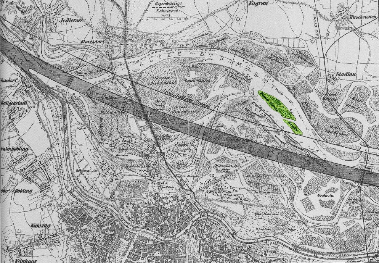
Donauverlauf erstellt durch eine zeitgenössische Karte des Donaudurchstichs
1870-1875 durch Raimund Hinkel; Floridsdorf


Flußbett der Donau vor der Begradigung

Verschiedene Gewässer und Landschaftsbezeichnungen Wiens und die in der Karte vorkommen


Donauverlauf erstellt durch den Plan des Marchfeldes und Wiens, 1824 mit den Grundrissen der Bahnsteige der Donaumarina und der Donaustadtbrücke


Montag, 22. November 2010

Light Projects, Melbourne

Islands Of Swarm

About design of Architecture and Community

"That is the first task of storytelling. It opens up a theatre in order to legitimize actual deeds. It creates a realm where daring and accidental public practice become authorized." Michel Certeau.


The emersion of theatre, in its closed architectural appearance as we know, takes part in the same time as the development of the new laws of perspective in the Renaissance and the establishing of the civil city-state. Similar to the paintings of the Renaissance, which put the viewer in front of a well arranged painting, architectures of theatres freeze the viewers gaze and their position in an orderly perspective and thereby produce an ideal sight.


Islands of Swarm, parts of the archive of stadium, theater and other associated areas


The exhibition originates from my archive about stadiums, theatres and associated areas. A design is found in a construction, which transforms the archive in a special form/ object and generates a special map. Starting from the idea that architecture is not a container for human neediness, but that people needs and humanness are rather generated through architecture. The exhibition asks about the disciplining function of architecture, it is about approaches of action and other practices in the architectural space that generate a “social sculpture”, which in its best way is discursive as well as performativ- practical and asks for the connectivity of architecture and community.


http://light-projects.com/index.php?/upcoming/islands-of-swarm/


Montag, 19. Juli 2010

Paradise - 11th International Garden Festival in Les Jardins de Métis / Reford Gardens

le balto invites Kai Schiemenz
Bois de biais: Ces jours-ci je suis fier de mon petit paradis
I’m So Proud of My Paradise These Days


June 26 to October 3, 2010

An Ambitious Program of Gardens
Recognized as one of the world’s leading garden festivals, the International Garden Festival features conceptual gardens that are at the crossroads of landscape architecture, garden design, architecture, design and environmental art. The event will take place on the site of Les Jardins de Métis / Reford Gardens from June 26 to October 3, 2010.

The 11th edition of the Festival will present 21 ephemeral gardens created by 65 designers from Australia, Canada, France, Germany, Italy, the Netherlands, United States and the United Kingdom. The lineup of conceptual gardens includes three new gardens by designers selected by a jury following an international competition and four new gardens created by designers from Berlin invited to take part in the Festival.


A garden is a space, in which we realize our beliefs in and our visions of social and natural ideal(s). It is an island, not a fathomless place such as Utopia. The garden is a showcase space, 1:1 implemented in the ground. It does not separate imagination from reality. For the 5th year of their garden called bois de biais, atelier le balto invited the Berlin based artist Kai Schiemenz to complete their landscape architecture. He suggested for their garden, which over time has almost become a forest of willows and poplars, to build a walkable structure out of wood. It paraphrases a type of a “folly”, where the visitor can enter and climb the stairs to the platform, to get an overview of the garden. But during the summer the trees will outgrow the structure and make it partially disappear. The sculpture works as an allegory that rewrites the beauty of a garden that grows into a forest.


scetch of I'm so proud of my garden, Collage


New Forms of Paradise
Since the beginning of time humans have imagined paradise on earth as a garden. These places, by evoking our senses, have pulled us out of our everyday world to experience the sublime. What does paradise look like today?

Building on emerging practices in landscape architecture, participating designers have been invited to imagine their garden of paradise; inspired by the history of gardening and exploring philosophy, religion and history and incorporating aspects of contemporary society and their own personal history to bring to life new forms, tastes, fragrances and paradisiacal landscapes.

Participating for the second time in the International Garden Festival, Berlin-based garden architects atelier le balto invited Kai Schiemenz to work with them for the 2010 International Garden Festival in the Jardin de Médis, Redford Gardens near Québec, Canada to install a folly in their previously designed garden "bois de biase".

The International Garden Festival is the leading contemporary garden festival in North America. Presented since 2000, the Festival has exhibited more than 115 gardens on the festival site and in Montreal, Toronto, France, Italy and the United Kingdom.


first modell

final modell

http://www.refordgardens.com/english/festival/garden-5-ces-jours-ci-je-suis-fier-de-mon-petit-paradis-bois-de-biais.php?EC=1

LUSH LIFE - at Lehmann Maupin Gallery

We are not here to make friends
Iris Flügel und Kai Schiemenz

LUSH LIFE – Chapter 4: Let it Die at Lehmann Maupin Gallery

An exhibition inspired by Richard Price's novel of the same title
Featuring Artists in Nine Lower East Side Galleries, New York


Lehmann Maupin announces its participation in LUSH LIFE, an exhibition curated by Franklin Evans and Omar Lopez-Chahoud and inspired by Richard Price's 2008 novel of the same title. LUSH LIFE includes 60 artists, and nine Lower East Side galleries, including Lehmann Maupin. Each gallery will feature a sub-exhibition reflecting the idea of one of the nine chapters in the novel. Evans and Lopez-Chahoud selected one artist from each gallery and solicited additional artist recommendations from each of them to participate in the exhibition.


Detail of, We are not here to make friends
Foam Core Board, Wood, Spanish Moss, Orchids, Oyster-Mushrooms


I‘m not here to make friends is built as a model of an air-garden, an air-garden of decay in an open cubic structure. Air plants, for instance Tillandsia and orchids, which take their nutrition out of the air and oyster mushrooms, which once they are seated in a cultur medium need no further nutrition.

A forest, growing at its own over years, decades, yet all the plants are rooted in the air. You can actually sit there and contemplate about Charles Darwin, everyday, every week, watching those slow and ancient roots push deeper and deeper into the earth. Worms crawl, as if through space, forming tunnels – underground landscapes of air.


Lehmann Maupin will represent Chapter Four: Let it Die and will exhibit the work of Jackie Saccoccio, Jessica Dickinson, Matthew Weinstein, Dani Leventhal, Rashid Johnson, Claudia Weber, Jose Lerma, Kai Schiemenz, Iris Fluegel, Robert Beck, Robert Melee, Tommy Hartung, Nina Lola Bachhuber, Cynthia Lin and Amy Longenecker-Brown. Chapter four in Price's novel addresses the attempt to ignore and let a story die, to allow for a neighborhood's history to die, and to actively bury the past and the difficulty of finding a fairer answer/resolution to a complex situation.

Both Jackie Saccoccio and Jessica Dickinson offer works that through their process-based painting and drawing emphasize the physical layers of residue to a literal past. Saccoccio's work looks to an earlier era (mid-century New York abstraction). Dani Leventhal's blood/skinning drawings, Matthew Weinstein's death-tracking skeletal hand and frisbee, and Rashid Johnson's literal death reflection mirror present the subject as non-elusively and frontal.

Claudia Weber, Jose Lerma, Kai Schiemenz, Iris Fluegel, Nina Lola Bachhuber, and Amy Longenecker-Brown will be making work specific to the consideration of both history passing (its death) and the neighborhood in transition, both themes of Price's novel. Robert Melee's and Tommy Hartung's sculptures challenge the ease to which a past can disappear and/or morph into a new form. Cynthia Lin's larger-than-life distorted drawing of skin has an allusion to a possible lifeless state. While, Robert Beck's site-specific shrine alludes to the shrine in the novel that emerges after the murder and erodes in a short week.

Collective Opening Reception
A collective opening of all participating galleries will take place on Thursday, July 8th from 6–9 pm, however, exhibition dates throughout June and July will vary for each gallery.

About the Novel
Price's novel is set in the contemporary Lower East Side and, through a murder investigation, exposes the dynamically changing community of the neighborhood, which despite its evolution retains a ghostly and vital link to its layered past. The deep and varied history of the neighborhood now includes the Lower East Side galleries as new community members. The premise of community is reflected in the cooperative nature of the galleries' and artists' participation in the exhibition, which uses Price's novel to critically consider concepts of neighborhood and change. LUSH LIFE will be the present for what will become a living ghost to the future form into which the Lower East Side will inevitably morph.

For gallery news and exclusive artist updates become a Facebook Fan of Lehmann Maupin. http://www.lehmannmaupin.com/


Media Contacts:
Lehmann Maupin
Bethanie Brady
212 255 2923
Bethanie@lehmannmaupin.com


Donnerstag, 27. Mai 2010

The Knot _ linking the existing with the imaginary – mobile unit for artistic production and presentation


House of the blurry edges

Kai Schiemenz in collaboration with Iris Flügel


THE KNOT is a mobile platform for artistic production and presentation that occupies different public places in the cities of Berlin, Warsaw and Bucharest from the end of April till end of October 2010.

Conceived as a nomadic, temporary site, THE KNOT creates an innovative framework for performing the habitual as well as the unexpected. It is a new site for experiencing different modes of interaction and cooperation, for exchanging theoretical and practical knowledge, and for testing various fields of engagement with the public sphere. The core venue for all project activities is a specially designed architectural structure, adaptable to the diverse urban situations it encounters, and inspirational for a wider discussion on the shapes of tomorrow’s agoras. In its lightweight, easily expandable form, the mobile unit fits a multitude of heterogeneous uses and creates a temporary and hospitable shelter for different activities, many of them simultaneous. The public is invited to take part in the production of the various projects.


Model for the house of the blurry edges


Possible choreography with the model


A structure like a three dimensional cube puzzle in the size of 200 x 200 x 200 cm. It is dimensioned to be transported in a truck with standard dimension 210 x 210 x 400 cm. It is built in four parts out of wood and painted with different colours of blackboard paint (black, green, plaid pink, grey). The main idea is that you are able to change the object in different types of use in refer to the needs.
It is an It-Could-Be-Structure, a useable display: as a platform, as theater, as a garden, as a monument or after all a simple sculpture. A choreographed sculpture which starts as a cube, like a Malevich’s Kaaba in Berlin and morphs during the whole voyage into an exploding observation point with a garden inside (very metaphorical) in Bucharest.
During this time the structure is an Everyone-Can-Use-Structure, a source for something else, something could-be, everyone is able to extend the structure in a temporarily sense, what means that after the using it should be possible to move the single parts back into each other - back to its innocent cubical form.


în progess in Tempelhof, Berlin


...

in Warzaw

...

in Bucharest


link: http://knotland.net/index.php?id=33
www.facebook.com/...KNOT-mobile-unit/181669342405